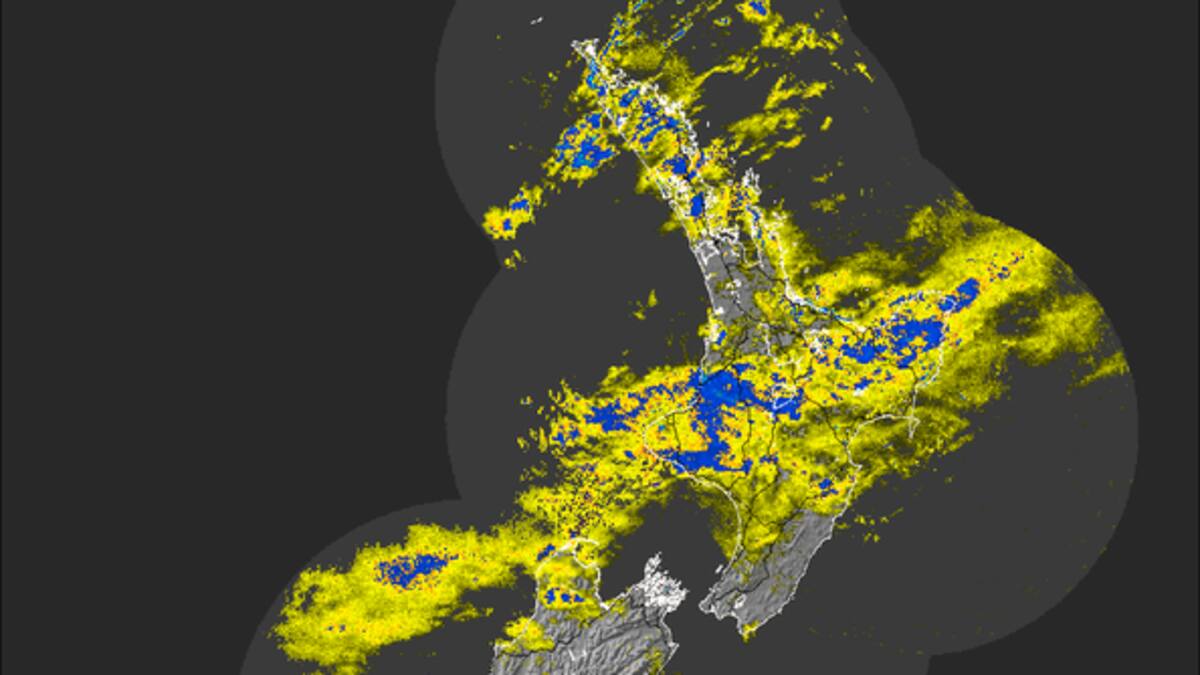
- Severe weather from ex-tropical Cyclone Tam caused flooding, power outages, and flight cancellations in the North Island.
- The cyclone’s impact will ease, but heavy rain warnings remain for Coromandel, Tairāwhiti Gisborne, and northwest Tasman.
- A second weather system is being monitored, with potential development early next week.
- Multiple townships on the Coromandel Peninsula are being isolated by flooding.
Coromandel townships have been cut off by flooding and more heavy rain is forecast to drench parts of the country as ex-tropical Cyclone Tam continues to cause havoc.
And as the fierce storm makes its way down New Zealand, forecasters are now monitoring a new weather system forming north of the country.
Flooding closed State Highway 25 overnight, isolating several Coromandel townships, with one person being rescued from their car as water rose rapidly around them.
The closure has left no safe highway access to Tairua, Whitianga or Coromandel township.
STORY CONTINUES AFTER LIVE BLOG
STORY CONTINUES
NZ Transport Agency Waka Kotahi said worsening conditions had forced the closure of SH25 Tairua to Hikuai at the intersection SH25A, and SH25 to Hikuai in both directions due to flooding.
Yesterday, gale-force winds tore off roofs, major roads were submerged by heavy flooding, and thousands of people were left without electricity.
Ferries and flights were cancelled, disrupting the travel plans of thousands of passengers, while trees downed by heaving winds smashed into cars, fences and houses.
On day three of Cyclone Tam, forecasters say the intensity and spread of weather in Auckland and Northland will begin to ease.
But looking towards next week, meteorologists are keeping an eye on a second weather system looming for New Zealand.

MetService forecaster Lewis Ferris said it still won’t be “picture perfect” for much of the country today.
The combined effects of wind and rain continued to pose a significant risk for those heading away for the long weekend.
As the weather system moves, northwest Tasman is set to receive intense rainfall, with a 54-hour deluge forecast from 6pm yesterday.
Niwa meteorologist Seth Carrier told the Herald that winds in the North Island would continue to ease today.
He said Tam’s remnants would slowly move away from New Zealand, and it might take until Tuesday or Wednesday for all the associated rainfall to end.
Second weather system bound for New Zealand next week
As the cyclone starts to weaken, a potential second weather system is now being watched closely by forecasters.
MetService meteorologist Mmathapelo Makgabutlane said there was a good chance of a low developing in the tropics, so they were keeping an eye on the region.
“With the low-pressure system itself, the real key will be where it forms and that will determine how deep it becomes once it forms,” she said.
Makgabutlane said the chances of the system developing into a tropical cyclone were low, but not impossible.
“We are still in tropical cyclone season, so this is a time when things are pretty active,” she said.
The system appeared to be tracking towards New Zealand from the northeast on Monday and Tuesday, but Makgabutlane said it was too early to determine if it would amount to anything significant.
“As the days go by, especially with all the other weather systems in play as well, once this low-pressure system develops we’ll have a clearer picture,” she said.

Niwa’s Carrier said a second cyclone was not expected to impact New Zealand in the coming days.
“However, the remnants of ex-tropical Cyclone Tam will continue to sit west of New Zealand during the holiday weekend and it will move very slowly.”
Cyclone Tam warnings and watches: Who is still in the firing line?
Ferris said the weather would remain generally unsettled, but the severe conditions in Auckland and Northland were expected to ease.
“Severe weather will continue for the Coromandel,” with several warnings still in place.
MetService said northern Tairāwhiti Gisborne and northwest Tasman may see a more prolonged period of rain today.
Both regions are under orange heavy-rain warnings from yesterday evening through to Saturday, with additional rainfall likely on Sunday.

MetService said Cyclone Tam will also influence conditions this weekend, bringing warm and humid air across the country.
Daytime highs on Saturday and Sunday may reach the mid to high 20s in the eastern and lower North Island – potentially record-breaking April temperatures for parts of Manawatū, Whanganui and Wellington.
Thousands were left without power in Northland, Whangārei and the Auckland region on Thursday as the cyclone barrelled across the country.
More than 10,000 homes remained without power last night.
Strong winds caused major damage to the Northpower network, with about 30 areas seriously damaged, much of this from trees falling through lines.
For the hardest-hit areas in Northland, Northpower warned the restoration may take two to three days.
Meanwhile, multiple flights, both domestic and international, were cancelled yesterday, with Auckland Airport warning more delays may be possible.
Thursday was the airport’s busiest day of the holiday period, with thousands of passengers transiting for their flights.
“Bad weather may continue to affect flight schedules, so our advice to travellers is to keep a close watch for updates from their airline if they are flying today or tomorrow,” an airport spokesperson said.


